search
Miami rail map
Miami train map. Miami rail map (Florida - USA) to print. Miami rail map (Florida - USA) to download. Miami is the southern terminus of Amtrak Atlantic Coast services, running two lines, the Silver Meteor and the Silver Star, both terminating in New York City. The Miami Amtrak Station is located in the suburb of Hialeah near the Tri-Rail/Metrorail Station on NW 79 St and NW 38 Ave as you can see in Miami rail map. Current construction of the Miami Central Station will move all Amtrak operations from its current out-of-the-way location to a centralized location with Metrorail, MIA Mover, Tri-Rail, Miami International Airport, and the Miami Intermodal Center all within the same station closer to Downtown. The station is expected to be completed by 2012. Florida High Speed Rail was planned to connect Miami with Orlando and Tampa in a single line, but was canceled in 2011.
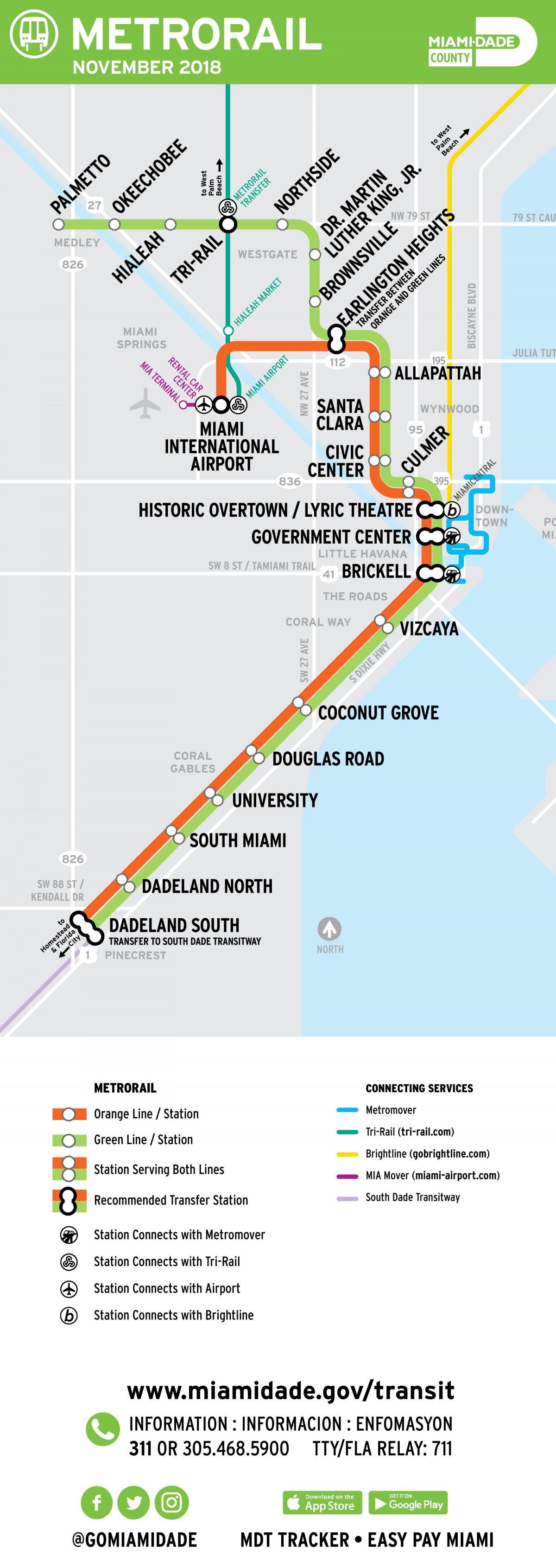
The Metrorail is a train that runs from the north to the south of Miami, with two lines covering 40 km and 23 stations as its shown in Miami rail map. The Miami Metrorail has several stops which are useful for tourists, such as Coconut Grove, Vizcaya Museum, Brickell Avenue or the Government Center. The Miami Metrorail runs from 5 am to 12 midnight. The Metrorail system is a 25-mile dual track that provides service to Miami International Airport (MIA) and runs from Kendall through South Miami, Coral Gables, and downtown Miami; to the Civic Center/Jackson Memorial Hospital area; and to Brownsville, Liberty City, Hialeah, and Medley in northwest Miami-Dade, with connections to Broward and Palm Beach counties at three locations: Historic Overtown Lyric Theatre station – transfer to Brightline, MIA (Orange Line) and the Tri-Rail (Green Line) stations – transfer to Tri-Rail.
Northbound trains travel to two different final destinations north of Earlington Heights Station: the Orange Line to the Miami International Metrorail station and the Green Line to Palmetto Station as its mentioned in Miami rail map. To identify the line a train is serving, look for the Green line or Orange line sign at the front of an approaching train. Also, look for the Green or Orange digital square on the side off all new trains. The same colored square is digitally displayed inside of each new Metrorail car. On northbound Orange Line trains, operators will announce the final destination for the train you are riding.


